CoPilot data setup guide
Contents
This document describes the data setup process for Walmart’s full rollout of CoPilot navigation with:
- NTransit integration for both stop locations and current vehicle and driver tracking
- The Platform Science Partner Gateway sync enabled
Note: These 2 components were not in place for the pilot from October 2023 to early May 2024.
There is a separate guide, prepared in conjunction with Platform Science, to cover hardware-specific rollout considerations.
Data flow to CoPilot
CoPilot requires several pieces of information to apply the correct settings to the correct devices and to successfully plan and execute routes. Walmart’s CoPilot workflow includes:
-
Routing information: NTransit will send CoPilot the stops for the current trip, the vehicle routing profile name, and the current vehicle and driver IDs.
-
Vehicle and driver information: The Platform Science partner gateway will send vehicles, vehicle groups, drivers, and driver groups to Account Manager. This information is stored in Account Manager under Configure Fleet Settings.
Custom location data for DCs
For all distribution centers, CoPilot will use the same map set, vehicle routing profiles, and configuration profile. The only difference among DCs is who maintains custom location data and which set is stored in ContentTools.
Walmart has six regions covering the U.S. George and Anthony will be responsible for creating initial custom places and route modifiers for all regions in the ContentTools web tool. Going forward, there will be one administrator for each region who is responsible for maintaining that region’s data.
Walmart’s ContentTools account will be organized into six custom place sets and six route modifier sets—one for each region. Each distribution center, store, and vendor will be assigned to one region. However, it is expected that vehicles will serve locations outside of their home region. Therefore, all sets will be assigned to all vehicles.
Requirements for location data
The following steps should be followed when DCs add new locations to ContentTools.
-
Identify which of the six regions the DC belongs to. Make sure any custom places or route modifiers are added within the set for that region. (This is for organization and performance reasons only. All tablets will work in all regions with no additional configuration necessary.)
-
For each DC, store, and vendor, make a new custom place. For stores with split grocery and general merchandise docks, make two separate pins, one for each dock. It is only necessary to duplicate a location when a store has separate General Merchandise and Grocery docks.
-
Use the naming convention of S/D/V, location code, city or vendor name, break allowance, and GR/GM when necessary to distinguish docks. Here are some examples:
- S 5911 Delray Beach, FL (Boynton) NO BREAK
- S 2814 (GR) Hialeah Gardens, FL OK BREAK
- D 6030 (GM) RAYMOND, NH OK BREAK
- V 49296747 Scotts-Hyponex (Palmdale) No break
-
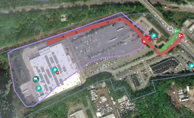
Draw the geofence, gates, and site paths as needed to define the first & last mile access to the custom place. When a store has multiple docks, each dock should have its own geofence, but the geofences can overlap each other. For each location, the geofence should cover the building(s), loading dock(s), parking lot(s), and private roads. The geofence must not cover the adjacent public roads. Use PC*Miler Web to test that routing is behaving as desired. Use route modifiers to avoid (or favor) certain roads in all cases.
Contact Trimble Maps support if it appears to be impossible to achieve the desired route path. Please include the origin and destination used for testing, the location name or number, and how the desired route differs from what’s shown in the app. Screenshots are helpful.
Tablet configuration
The following settings will be the same for all regions to ensure that all tablets receive the same Trimble map data and Walmart custom data.
Settings in Account Manager
Below are the settings that should be applied in the Configure Fleet Settings section of Account Manager.
Map Sets**
- North America - Assigned to all vehicle groups and marked as default
- It is possible to assign map sets to vehicle groups so that, for example, only vehicles entering Canada get the full North America data while the rest get only the United States data.
- Region 1 - Assigned to all vehicle groups and marked as default
- Region 2 - Assigned to all vehicle groups and marked as default
- Region 3 - Assigned to all vehicle groups and marked as default
- Region 4 - Assigned to all vehicle groups and marked as default
- Region 5 - Assigned to all vehicle groups and marked as default
- Region 6 - Assigned to all vehicle groups and marked as default
- 53ft Default - Assigned to all vehicle groups and marked as default
- 53ft Hazmat - Assigned to all vehicle groups and marked as default
- NTransit Integration - Assigned to all vehicle groups and marked as default