Introduction to CoPilot v10
Contents
Delivering your optimal route for over 25 years, designed to fit any fleet.
With CoPilot v10.4.0, the commitment to successful navigation has continued to evolve.
This updated and enhanced version includes a redesigned, more user friendly UI - helping to aid in overall ease of use so that you get more done, quicker and safer.
Core features have been enhanced across the product to provide improved results. To continue to provide CoPilot’s high level of performance, general bug fixes have also been executed.
Note: The CoPilot UI is subject to change and the version received may not match the deployed application.
New Features
Enhanced User Interface
The CoPilot User Interface (UI) has been redesigned and updated to provide a new look and feel to CoPilot. The modified design allows for a quicker user experience, with less clicks necessary to reach a particular feature as well as larger buttons for improved ease of use. The graphics have been developed to provide an enhanced engine within CoPilot deployments implementing Open GL. This allows for an improved graphics and enhanced map layer display.
Additional improvements to the UI include the automatic display of alternate routes when viewing your route. Alternate routes are shown with the ETA calculations for easy comparison.
Overall map performance has been improved to provide better results when panning and viewing maps within CoPilot. Through updating graphics, these enhancements to the map performance have been realized.


When a destination has been set and navigation is due to start, a warning will be displayed to the driver reminding them of legal implications and personal liabilities. The warning will be shown to the user after each new route is calculated, unless the “Don’t show me again” option is selected.
Speed limit display within the navigation screen must also be enabled which can be done via the Settings > Safety Alerts & Warnings screen.


The option to drag your route has been replaced with the option to select a location directly on the map to route through, or avoid. Once a point on the map has been selected, users can expand the option, indicated by the blue arrow icon on the map screen above. This will then allow the user to select Set as New Trip, Avoid This Road, or Route Through Here.
Searching for a destination is now even easier and can be found by selecting the search magnifying glass icon. Once you have selected the search icon, you will be taken to the new CoPilot search screen. Here you can find a destination by searching through various means, including saved favorites, address search and POIs.


The address entry screen has been updated to allow users to easily geocode locations. As shown in the screenshot above, the ability to enter the city and street address on the same screen has been included.

Menus have been redesigned into grid displays. This includes the Settings Menu which provides all settings options available to users. These categories have been refined to provide the easiest way to find the appropriate setting. Combining settings into groups allows for easier identification and customization.
CoPilot v10.4.0 still maintains the ability to customize the User Interface. Due to the design changes that have been made, many of these configuration values have been updated. Please refer to the CoPilot v10.4.0 user interface customization documentation.
Within Windows devices, scroll bars have also been introduced to ensure users are able to navigate through the available options quickly and easily.
Truck Specific Enhancements
Together with the general improvements provided within CoPilot v10.4.0 truck specific enhancements have also been made.
CoPilot Truck now supports three categories of trucks in all markets: Heavy, Medium and Light Duty. These three vehicle types support dimensional restrictions. Heavy and Medium Duty continue to support Hazmat and Tunnel routing as well as Light Duty supporting Commercial Plate Restrictions and Propane Restricted Tunnels within the NA market.
Truck routing profiles support the input of dimensions to ensure routes are provided on legal roads. Each truck type has default values but these can be amended by entering a custom dimension to ensure all truck sizes are captured. Each truck vehicle type has a maximum and minimum dimensions that can be entered, This aligns the type of routing to the vehicle type to ensure suitable routes are provided. Depending on the vehicle size, a different vehicle type should be used within the routing profile. The table below provides details on what is supported within each of the vehicle types.

CoPilot Routing Profile Menu
The values below denote the range of values and attributes that can be entered for the three different truck vehicle types.

Improvements have been made to the company management of routing profiles available to drivers. When using company managed routing profiles generated through Account Manager, CoPilot Truck has improved it’s handling of forced routing profile selection and the overlap with driver managed routing profiles.
Traffic
Improvements to North America traffic include INRIX XD™ Traffic as the the data provider. This improved service continues to provide live traffic information to CoPilot when licensed and now fully supports road closures.
Outside of North America, traffic has been updated to receive information from HERE Real-Time Traffic. Improved traffic data will only be available to CoPilot when users are licensed accordingly. When traffic is licensed and ActiveRoutes are enabled, users will be provided with more accurate ETAs. Historical traffic information will be taken into consideration when the live service is not available, or disabled.
Traffic updates now take place in a staged approach over both distance and time. To ensure updates are received ahead of time, they will take place more frequently whilst maintaining traffic data for later use.
When ActiveTraffic is enabled and a route is calculated, CoPilot will retrieve traffic information for the entire route. The calculated ETA will be derived and provided directly through the CoPilot UI. Following this initial retrieval of traffic information, CoPilot will initiate a staged approach to receive further updates.
- Every 2.5 minutes, a scan will be performed on the next 15 miles of the route
- Every 5 minutes, a scan will be performed on the next 30 miles of the route
- Every 10 minutes, a scan will be performed on the next 60 miles of the route
- Every 15 minutes, a scan will be performed on the next 90 miles of the route
At any one time, only one scan will be made for traffic information. For example, after 10 minutes, one scan for traffic over the next 60 miles will be performed. The 2.5 and 5 minute scans will not be made as the distance will be covered within the 10 minute scan.
These scans will be processed by CoPilot and update the ETA, if required. An alternate route option will also be provided when a route that potentially saves the driver 10 minutes or more can be found.
For example, the following scans will take place over the first 30 mins of a 250 mile journey.
| Time (Minutes) | Distance (Miles) |
|---|---|
| 0 | 250 |
| 2.5 | 15 |
| 5 | 30 |
| 7.5 | 15 |
| 10 | 60 |
| 12.5 | 15 |
| 15 | 90 |
| 17.5 | 15 |
| 20 | 30 |
| 22.5 | 15 |
| 25 | 60 |
| 27.5 | 15 |
| 30 | 90 |
CoPilot First Install Recommendations
Following the initial install of CoPilot it is recommended that the application is restarted to ensure full functionality is provided within CoPilot. This should take place following licensing and once the map data has been loaded.
Enhancements
Stop Arrival Logic
Improvements have been made to the logic defining when CoPilot registers a stop as arrived. Alignment has been improved between trip completion and final stop arrival on routes defined using RouteSync or TripDirect and trips monitored with Route Compliance.
CoPilot will present an Approaching Notification for every location included within the stop list. If there are multiple stops at the same location, only one notification will be provided. Upon the notification, the stop will be removed from the stop list.

Clear Stop Logic

CoPilot continues to provide an option for users to clear the destination whilst still on the navigation screen. A button can now also be enabled on the navigation menu to allow the user to clear the destination without having to expand into the CoPilot menu structure.
Further details on enabling this feature can be found within the customizing CoPilot v10 user interface document.
Guidance Instruction Improvements
CoPilot guidance has been enhanced to provide clear, more useful instructions to users. These enhancements have refined instructions, removing additional words that are not integral to the instructions. Users can now be informed when they are approaching a multiple lane road, and need to go in a certain direction.
Instructions on roundabouts have been improved. Clarifying direction and removal of complex and duplicate instructions has been carried out to provide clear, concise information. These enhancements improve the directions provided in complex scenarios with easy to follow instructions.
POI Improvements
CoPilot maintains millions of POIs across the various map data sets supported within the application. To further improve and build upon the information that is available to users, search functionality has been updated.
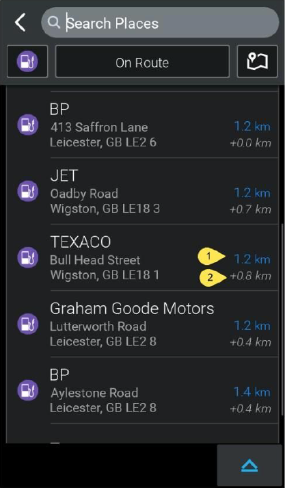
When a route has been planned and navigation is being provided, CoPilot will now allow users to search for POIs on the route, providing information on how much of an impact detouring to that POI will have on the current route. An On Route search option can be used when searching for a POI via the navigation screen quick menu.
Distance information is illustrated in the screenshots below. The user is provided with three different distances which show the impact on the route as well as the distance from the current location. Numbers have been added as reference points to illustrate the different distances.
- Shows how far along the route the POI is. This is done by finding the closest point on the route to the POI. As shown below, we can see that the TEXACO is 1.2 km along the route.
- Shows the impact on the trip, for example by visiting the TEXACO this would add a total of 0.8 km to your journey.
- Shows the straight line distance from your current location to the POI.

There are different options available for users to search POIs. Near Route is an additional search option, which allows users to search for POIs based on the route they have already calculated. This searches a wider area compared to the On Route option but still provides the overall impact on the journey. The Near Route option can be selected once a route has been calculated and by searching via the Plan Trip screen and when selecting Add Stop select the desired POI category and select Near Route .
Android Specific Enhancements
Upgrades to Android OS have improved the default Android Location Based Services framework for GPS connection.
Android platforms now support functionality to launch an external application from the CoPilot navigation screen. This can be enabled through additional user interface configuration settings which are detailed within the CoPilot v10.4.0 customizing user interface document.
Windows Mobile and WinCE Specific Changes
To ensure optimal performance is maintained within Windows Mobile and Win CE the ability to download map data Over the Air (OTA) is not available. Manual map data updates are still available on these platforms. For further information on how to update map data please speak to your Trimble Maps Account Manager for options available to you.
Geocoding
Geocoding logic has been updated when both Address and Latitude/Longitude details are provided to CoPilot. CoPilot will look to match the street name provided within a 1 mile radius of the latitude and longitude coordinate. If the street name is found within this threshold distance, CoPilot will provide a destination perpendicular from the coordinate to the street. This will not take into consideration the house number, even if it has been provided.
If the street name that has been provided cannot be located within the 1 mile radius from the coordinate, CoPilot will provide a destination perpendicular to the coordinate on the road closest to this location. In this case where the street cannot be found, a call back of ERROR_STREET_NOT_FOUND will be provided to indicate this.
Routing
CoPilot routing has been improved to provide better routes for users. By enhancing the routing logic, users will receive the best possible routes whilst continuing to take into account the parameters set within the routing profile.
Truck routing profiles support dimensional restrictions across all three categories: Heavy, Medium and Light. Further details on the specific attributes available in these three vehicle types can be found within the Truck Specific Enhancements section of this document.
Motion Lock
Motion Lock restricts the use of the CoPilot UI when the user is driving. To ensure there is no distraction by using CoPilot, the UI options are disabled when in motion. This has been further refined within CoPilot v10.4.0. Whilst the majority of the options are disabled via Motion Lock, there are some features which remain available to the end user. Users will be able to toggle between map views (2D, 3D or Safety View), pan the map, use the zoom options and clear the destination.
RouteSync / TripDirect
CoPilot now notifies the driver upon delivery of a new RouteSync or TripDirect route and then prevents creation or modification of a trip while the new route is being processed. The driver then receives notification that the new route is ready to be followed. Further details on these improvements can be found within the CoPilot feature documentation.
CoPilot Integration
CoPilot can be integrated with third party applications through either the CoPilot SDK or CPIK libraries. The release of CoPilot v10 has seen a new UI introduced as well as other integration improvements. This has also led to a number of APIs being deprecated. This does not mean functionality has been removed, only that better ways of achieving the same result have been introduced.
CoPilot SDK
Please note when upgrading from CoPilot V9 to CoPilot v10, the integrated SDK application requires a V10 DLL. CoPilot DLL is not backwards or forwards compatible between major release versions. CoPilot v10 requires the V10 DLL to ensure full functionality is provided. This applies to all supported platforms.
New API Enabled Functionality
CoPilot SDK has been enhanced to include a set of APIs which download map data. This includes the ability to stop, pause or check the download status. Further information relating to these APIs can be found in the SDK documentation.
Deprecated SDK APIs
A number of APIs have been Deprecated in CoPilot v10.This is due to better alternatives existing within CoPilot or no longer being relevant in the latest update. The deprecated APIs can be found in the following table.
| Deprecated API | Notes |
|---|---|
| MSG_IDT_DESPITEDIST | Deprecated due to improved guidance commands and as a result this API is no longer required |
| MSG_IDT_WALKINGMODE | Msg_SendRoutingProfile should be used to set the routing profile to walking mode rather than using this API. As a result this API is being deprecated. |
| Msg_SendResizeCoPilot | CoPilot should be used in full screen view on a device and it is not often required to input a custom screen size. This API is no longer required. |
| Msg_SendTripDetour | Functionality removed from CoPilot v10 |
| MSG_IDT_NAVMODECHNG | Msg_SendRoutingProfile should be used to change the routing profile settings on CoPilot. This value used to change the routing type within the routing profile is as a result not required. |
| MSG_IDT_NAVMODE | Msg_SendRoutingProfile should be used to change the routing profile settings on CoPilot. This value used to change the routing type within the routing profile and as a result, not required. |
| MSG_IDT_COMPASS | Removed from CoPilot v10 |
| MSG_IDT_LIVELINK | Previously MSG_IDT_LIVELINK was used to enabled live features. Individual live feature can be enabled by specific APIs and as a result this generic command is no longer needed within CoPilot. |
| Msg_GetTurnInstructions | Msg_GetTurnInstructionsEx has been implemented providing further details on the turn instructions available through CoPilot. This includes more detail and as a result Msg_GetTurnInstructions can be deprecated. |
| Msg_SearchPOI | Msg_SearchPOIEx should be used instead of this API as it provides additional functionality. |
| Msg_SetMapPan | Msg_ZoomToStop can be used to pan the map to a specific point. The option remains within the CoPilot UI to also carry out this functionality and as a result Msg_SetMapPan has been deprecated. |
| Msg_SendResizeMap | CoPilot should be used in full screen view on a device and it is not often required to input a custom screen size. This API is no longer required. |
| Msg_GetGuidanceMapSize | Related to Msg_GetGuidanceMap this API so also no longer required due to functionality of Msg_GetGuidanceMap being deprecated. |
| Msg_GetGuidanceMap | Used to return a GIF image of the guidance map, users can use the Msg_ShowGUI to display the navigation screen when required. Msg_GetGuidanceMap is as a result. No longer required. |
| Msg_GetGuidanceMapSizeSharedMem | Used to add a CoPilot window within client applications. No longer required due to development of CPIK integration which meets these requirements for a CoPilot window within client applications. |
| Msg_GetGuidanceMapSharedMem | Used to add a CoPilot window within client applications. No longer required due to development of CPIK integration which meets these requirements for a CoPilot window within client applications. |
| Msg_SharedMemNotifierWaitForEvent | Used to add a CoPilot window within client applications. No longer required due to development of CPIK integration which meets these requirements for a CoPilot window within client applications. |
| Msg_SharedMemNotifierClearEvent | Used to add a CoPilot window within client applications. No longer required due to development of CPIK integration which meets these requirements for a CoPilot window within client applications. |
| Msg_SendManagedRoute | Msg_SendManagedRouteJSONZoomToStop should be used instead. RouteSync input files should no longer be sent in a .txt format as JSON provides a better results. |
| Msg_MapUpdate | We no longer produce and distribute map diffs which were passed to CoPilot to provide an update to the map data. As a result this API is no longer needed. A new set of Map APIs have been included under Msg_DownloadMap to provide map updates. |
| Msg_AddMapUpdateCallback | Related to Msg_MapUpdate and is no longer required. |
| MsgHandlerMapUpdate | Related to Msg_MapUpdate and is no longer required. |
| Msg_SearchCity | No longer required due to the introduction of Msg_SearchCityAndPostcode |
| Msg_SearchPostcode | No longer required due to the introduction of Msg_SearchCityAndPostcode |
For further details on the replacements for this functionality please refer to the SDK API documentation.
CPIK
New API Enabled Functionality
A new set of APIs to control and request the download of new map data have been introduced to CPIK. These APIs allow integrated applications to check the availability of new map data, request the download of map data and also the status of any download that may be in progress. Full details of these APIs can be found within the CPIK API documentation.
CPIK now supports the receipt of a full trip itinerary via API. This can be requested and with updates sent based on routing events if any changes occur to the itinerary. The full list of these events including the specific API details, can be found within the CPIK API documentation.
An additional callback has also been added, to be returned when a user has left the navigation screen.
Deprecated CPIK APIs
View a full list of deprecated APIs
CoPilot Deprecated Features
Due to the redesign of CoPilot, some features are no longer present within the product. This includes the Fuel Cost display, Google Search and also the ability to display a compass on the navigation window.
Detours are no longer supported within CoPilot. This feature has been removed from the CoPilot UI as well as deprecating the related APIs.
Supported Platforms
CoPilot is currently supported on the following platform versions for standalone, CPIK libraries (CPIK) and SDK app deployments:
Standalone CoPilot GPS
| Platform | Minimum Supported Version |
|---|---|
| Android | 7 |
| iOS | 12.2 |
CoPilot CPIK Libraries
| Platform | Minimum Supported Version |
|---|---|
| Android | 7 |
| iOS | 8 |
CoPilot SDK App
| Platform | Minimum Supported Version |
|---|---|
| Android | 7 |
| Win32/64 | Windows 10 |
Storage requirements
When unpacking the installation files, CoPilot requires at least twice as much free disk space (200MB for CoPilot, so 400MB of free space). After the installation of CoPilot, the unused space is released again.
You will also need sufficient storage space to store map data on the device. The amount of space needed varies depending on the map region you are installing, but typically:
- A single European Country or North America region requires roughly 300 to 700MB
- Complete European maps require approximately 4GB
- All of North America (Canada + USA) requires 2.5GB
In North America, smaller map regions can be created using the mapsets feature in Account Manager. (Requires CoPilot 10.19 or later)
Minimum hardware requirements for Android
In theory, if your device has the specs to run Android, it can run CoPilot but below is a recommended guide based upon our observations using Android:
Processor
- ARM
- x86 – can be supported but recommended to inform us if using this architecture
- Recommended clock speed 1GHz+
RAM
- Recommended 512MB
Screen
- Minimum resolution 240x320 pixels
- Recommended at least 320x480
- Currently no known maximum
OS
- CoPilot supports devices using a minimum of Android 7