Speed Limits
Contents
Posted auto and truck speed limits are available throughout the world as an add-on for our Location APIs. With this information, you can analyze whether drivers are obeying speed limits as a way to:
- Improve driver safety and reduce risk of accidents
- Improve fuel efficiency and reduce carbon emissions
- Reduce the risk of traffic tickets and fines
- Improve operational efficiency and costs
How does it work?
Watch VideoOur Reverse Geocoding API takes in GPS coordinates and returns an address and other information about that location. As part of that API call, you can request the posted speed limit for the road link at that location.
What factors does the API consider when retrieving speed limits?
Speed limits can vary by vehicle type and type of road. To extract the correct road speed limit, the API takes into consideration:
- The vehicle type - Auto or Truck (Light Truck, Medium Truck, or Heavy Truck)
- The GPS coordinates (lat/lon) of the location
- The vehicle’s direction or bearing. Some roads may have at the same location different speed limits for each direction.
- The vehicle’s “current” speed, which is its recorded speed at that location. Vehicle speed helps determine which road link in the data the driver was on, especially in areas with multiple criss-crossing roads with different posted speed limits.
What types of speed limit data are available?
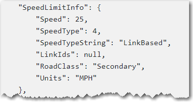
Automobiles
For each road segment (“road link”) we return the speed limit associated with the link. On certain roads, the speed limit can differ in each direction, therefore the heading information is relevant to ensure that we return the correct speed limit.
Trucks
There are special speed restrictions for trucks in many places. In addition to road specific speed limits, many countries and some states have jurisdiction wide speed rules (JWR) for trucks. Usually they apply for the whole country or state and are related to a road category. An example would be the maximum truck speed limit of 80 km/h on all motorways in Germany.
Our platform deals with this complexity by selecting speed limits in the following order:
- If there is a dedicated truck speed limit associated with the road segment and direction, we return this.
- If there is no dedicated truck speed limit we return the lower value of the auto speed limit and the JWR speed limit.
- Example 1: A national road has no specific truck speed limit and has an auto speed limit of 50 km/h. The JWR speed limit for trucks for national roads is 60 km/h. We return 50 km/h as the speed limit
- Example 2: A national road has no specific truck speed limit and an auto speed limit of 70 km/h. The JWR speed limit for trucks for national roads is 60 km/h. We return 60 km/h as the speed limit
Can a customer provide their own speed limits?
For automobiles only, our licensed MapExact web tool allows you to edit the speed limit assigned to a road link. If you have submitted a speed limit override for the geocoded link, that value will be returned by the Reverse Geocoding API.
What can you do with speed limit information?
Backend systems integrating Trimble Maps can make use of the API to get speed limit data and integrate it with data received from the vehicle’s telematics device.
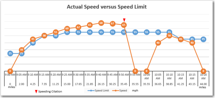
For example, the posted speed can be compared with the actual speed recorded at the same location by the telematics device.
Share this article: