Traffic
Contents
Traffic is a licensed service that provides a combination of historical and real-time traffic information to improve routes and to calculate accurate travel time predictions. All descriptions in this document assume that traffic is licensed.
Who provides the data for the traffic service?
In North America, traffic data is provided by INRIX. Outside of North America, HERE provides the traffic information used within our products. Country specific information about availability of traffic information.
Traffic data overview
Traffic data is made up of two components: Historical traffic patterns and real-time traffic information.
- Historical traffic patterns. This information is integrated into our map data and provides highly granular historical average road speeds per street in 15-minute intervals for each day of the week. If the day and time of travel are known when calculating a route, our solutions may use that information to 1) calculate realistic ETAs based on real-world average speeds and 2) (Recommended for cars only) to intelligently calculate the fastest route for any particular time of day or day of the week.
- Live traffic. This is the current traffic information for a specific route or map area. It includes real-time traffic flow information, road closures and significant traffic incidents. It is used to dynamically compute precise real-time arrival times, and calculate routes that avoid closed roads and severe delays.
How does traffic information influence the outcome of route calculation, ETAs and guidance?
- Realistic drive times. A route is made up of a large set of road segments (links). Each segment has a distance and travel speed and this enables us to calculate realistic drive times and ETAs.
- Average speed-based routing. Specifically for car and van routing (not for use with tractor-trailers or articulated trucks) we are able to calculate routes with the fastest travel time based on historical traffic speed patterns.
- Avoiding closed roads. When calculating a route, closed roads that are identified in our live traffic feed are avoided wherever possible
- Dynamic ETAs. When in guidance mode on a mobile device, the remaining estimated travel time (ETT) and arrival time (ETA) are constantly updated based on live traffic conditions ahead.
- Rerouting around severe delays. Once on-route, if significant delays occur CoPilot may calculate an alternate faster route. Note that for truck routing any alternate route also needs to take relevant truck restrictions into consideration making it less likely to find faster alternatives.
How is traffic used within the Trimble Maps platform?
The usage differs by use case and which component of our software platform you are using. Depending on the use case, we apply historical traffic, live traffic, or both.
Backend route planning (PC*Miler, JavaScript Maps, Web APIs)
When planning a route for the vehicle type, “Auto,” and the route type, “Fastest,” historical traffic speeds are used to compute the initial route. The Fastest route type should not be used for truck routing as it could take the truck on less suitable, smaller roads. For trucks, the route type “Practical” is recommended in combination with historical traffic speeds to provide a realistic travel time and ETA.
Calculating travel times in advance: When planning a route in advance for a specific date and time, historical traffic speed patterns are used to calculate Estimated Travel Time (ETT) and corresponding Estimated Time of Arrival (ETA). If a start date/time is not provided, standard average speed assumptions per road-class are used.
“Depart Now” travel times: When the start time is “now”, a combination of live traffic and historical traffic is used to compute ETT and ETA. Live traffic is applied to the first 60 miles/90 kilometers, beyond which historical traffic patterns are used.
Back Office traffic visualization (PC*Miler, JavaScript Maps)
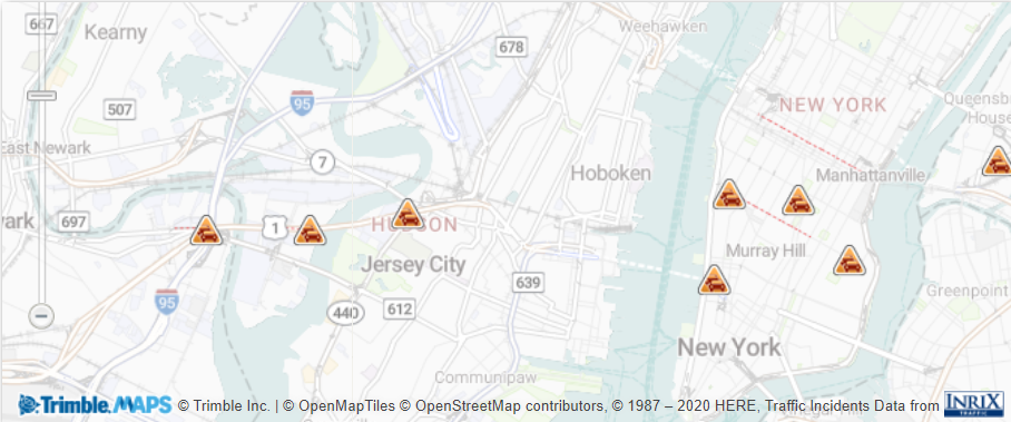
A combination of a vehicle position, a route path and current traffic is frequently used by dispatchers monitoring the status of their fleet. To facilitate this, a color-coded (green, yellow, red) traffic layer can be shown on top of the road network to provide real-time visibility of the traffic conditions on a route or a map area you are viewing. In addition, significant traffic incidents are also displayed—for example lane closures, congestion, or road construction, along with any available further details about the incident.
Traffic Flow
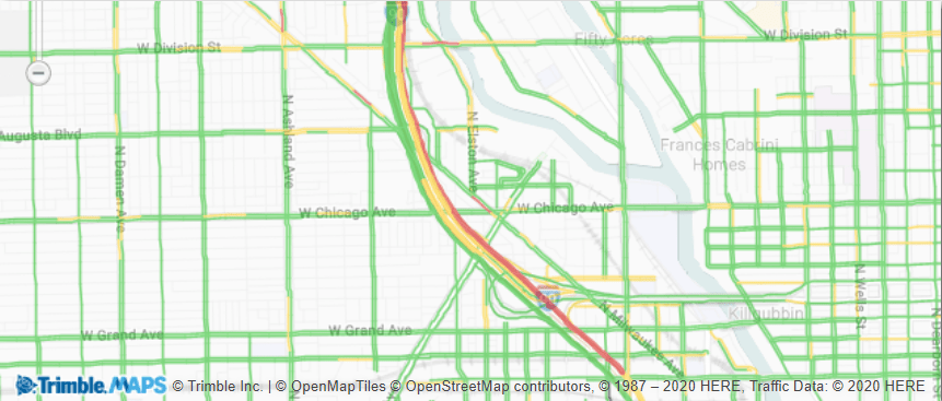
Traffic Incidents
CoPilot on-device navigation
CoPilot mobile navigation can use both live and historical traffic to calculate travel time and ETA and, depending on the vehicle routing profile, the initial route itself. Historical traffic information is stored locally on-board the device along with the map data. Real-time traffic is accessed dynamically via a mobile internet connection.
Once the initial route path options are calculated (a choice of up to 3), CoPilot requests the traffic information for each from the server and updates the ETA taking into account live traffic conditions. If a closed road is detected the routes are recalculated. Any significant traffic incidents on-route are displayed in the route planning screen.
Live Traffic
Live traffic information is used to compute initial travel times for the first 60 miles of a route while historical traffic speeds are used for the remainder of the route. This is to account for traffic fluctuations that may occur after this distance.
Once the user has chosen a route and starts guidance, CoPilot will regularly check the route ahead for Live traffic and dynamically update the travel time accordingly.
To minimize mobile data consumption while keeping relevant traffic conditions as up-to-date as possible, a distance-based refresh logic is applied where Live traffic closest to the current position is checked more frequently. Traffic information farther ahead is refreshed less as it will likely change during drive time.
Live Traffic refresh intervals :
- Next 15 miles, a scan every 2.5 minutes
- Next 30 miles, a scan every 5 minutes
- Next 45 miles, a scan every 10 minutes
- Next 60 miles, a scan every 15 minutes
Mobile data consumption for Live traffic varies depending on several factors including trip distance, duration and the frequency of route calculation and re-routing.
How is Live traffic information shown to the driver?
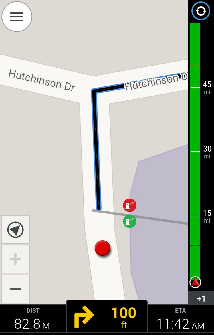
Traffic Bar
A traffic bar is displayed on the right side of the driver’s guidance screen in CoPilot navigation. This shows the color-coded (green, yellow, red) traffic conditions for up to 60 miles / 90 km of the route ahead. Distance markers are applied for clarity. If you have more than one stop planned in your trip, traffic information is only shown for the first stop.
- Green = traffic flow is normal, no unusual slow down
- Yellow = slow moving traffic but still flowing
- Red = standstill with bigger impact on travel time/ETA
- Black = A road segment is completely closed. In this case, CoPilot will attempt to calculate an alternative route.
At the bottom of the traffic bar, the overall traffic delay time is displayed in minutes, color-coded based on severity. This delay time is reflected in CoPilot’s continuously updated overall trip ETT and ETA.
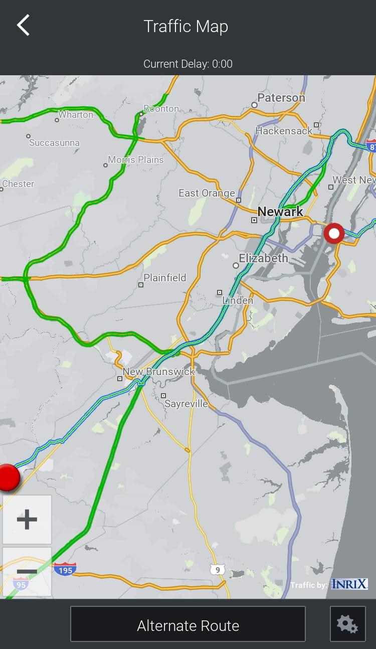
Traffic Map
(CoPilot 10 only)
To view a more detailed overview of the traffic situation, a traffic map can be displayed by tapping on the traffic bar. For safety purposes and to avoid distraction to the driver, the traffic map is not shown constantly.
The traffic map is similar to the traffic overlay in our backend map display. Roads are colored according to the traffic speed and small icons represent the traffic incidents.
Detours to avoid heavy traffic
If the traffic ahead is causing a significant delay of more than 10 minutes AND CoPilot finds an alternate route that is quicker, the alternate route is suggested to the driver. The driver needs to accept the alternate route or can choose to stay on the current route.
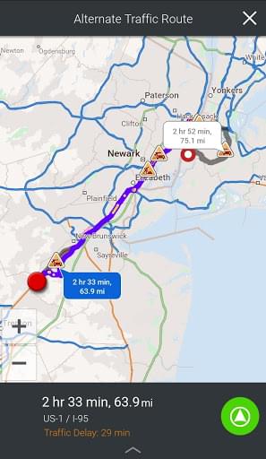
In many cases, it is faster to stay on the current route than to use a detour typically using smaller roads and, in case of major traffic incidents, also impacted by lots of other drivers choosing the same alternate route. CoPilot tries to balance this accordingly. This is particularly the case for trucks where a detour may be not suitable due to lower road classes or physical or legal truck-specific road restrictions.
Sudden slowdown alerts in CoPilot
First available in CoPilot 10.19.0.1405
CoPilot provides warning alerts for trucks when a sudden traffic slowdown is detected ahead on an interstate (North America) or motorway (Europe). The alert is issued up to 5 miles (8 km) before the traffic incident to give the driver time to slow down and potentially avoid an accident. Alerts are provided as voice only or voice with a pop-up message.
The slowdown alert is active only when CoPilot is using a Vehicle Routing Profile for a truck or school bus and the driver is traveling on an interstate or motorway. It is not available for smaller vehicles (cars, caravans and motorbikes). The alerts are also not issued if traffic in the slowdown area is already moving slower than 40 mph.
Watch VideoFurther details
Specific details how to set parameters/apply traffic to routing and visualisation can be found in the respective parts of our CoPilot developer documentation.
Share this article: