Truck Routing
Contents
Trimble Maps generates truck routes that adhere to restrictions based on a vehicle’s dimensions, load (hazmat) and vehicle type. Our truck routing also takes into account a fleet’s preferences for how a vehicle should be routed, which can be set using a Vehicle Routing Profile.
In order to find the most appropriate route for your vehicle, our truck routing considers:
- Physical restrictions – These are road restrictions based upon the vehicle dimensions provided. Routes will avoid any road that is known to be unsuitable or forbidden for the vehicle being driven. (For instance, if the vehicle height is above that of a low bridge on the road.)
- Legal Restrictions – These are roads that are legally restricted to all vehicles or restricted specifically to trucks. That includes roads specified as “No Thru Traffic” or “Delivery Only,” which will be used in routing only if a delivery or pick-up stop is on that road.
- Road Classes – Truck routing has been configured to avoid lower classes of roads, such as local roads, wherever possible. Instead, truck routing favors higher classes of roads including highways, motorways and dual carriageways.
- U-Turns – Performing a U-turn is very difficult in a truck, and our routing algorithm has been configured to strongly avoid U-turns. It will try to find an alternative route, which may be up to 20 miles.
What is a Vehicle Routing Profile?
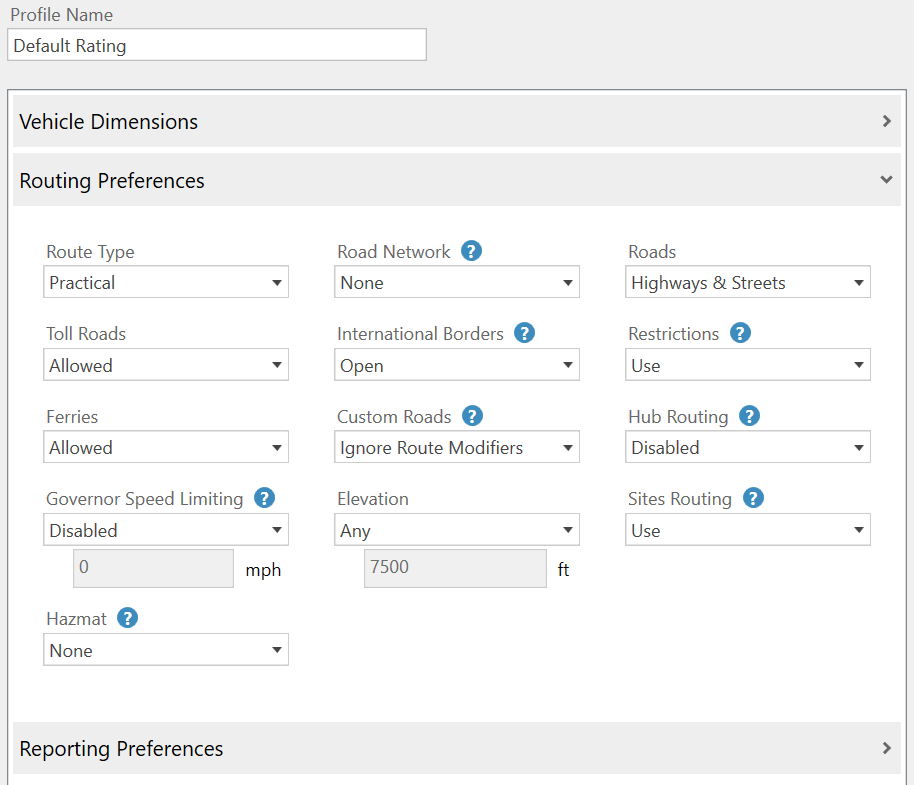
A Vehicle Routing Profile is a collection of settings that ensure our routing algorithm knows the type of vehicle being driven, so it can apply all road restrictions when generating the route. Our applications include Vehicle Routing Profiles for common vehicle types, such as Heavy Duty Semitrailer (U.S.) and Heavy Articulated (Europe). These standard profiles can be used “out of the box” or customized for your fleet with settings including:
- Custom vehicle dimensions.
- The routing type – Practical or Shortest.
- (North America only) Whether to avoid toll roads or roads above a certain elevation.
- Whether to apply hazmat road restrictions to the route, including ADR tunnel codes in Europe.
- A governor speed limit for use in ETA calculations.
- Whether to allow the route to cross international borders or use ferries.
- (U.S. Only) Whether routing should favor the National Network, which includes the Interstate System (several minor segments are not included), and many selected U.S. and state highways.
- (Europe Only) Whether to route through or avoid congestion charge zones, low emissions zones, and the ultra low emission zone (ULEZ) in central London.
What’s the difference between Practical and Shortest routing?
We offer two basic choices for generating truck routes: Practical and Shortest. (A third routing type, fastest, is available in some products but not recommended for trucks.)
-
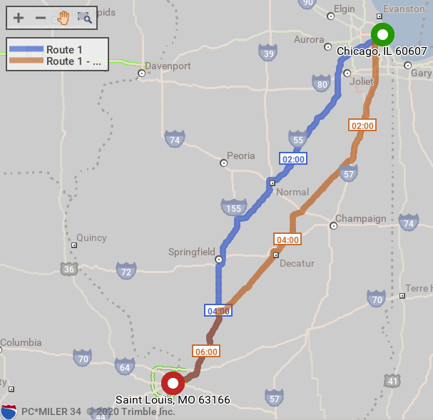
Practical routes will choose the quickest route that is suitable based upon the selected Vehicle Routing Profile. This adds significant favoring to highways, motorways and dual carriageways, and only uses local and secondary roads if essential to reach your destination. Practical routes consider distance, road classification, terrain, urban/rural classifications, and truck-restricted roads.
-
Shortest routing will generate a straighter route, but potentially a route that will take the driver a longer time. Shortest routes represent distances and driving routes that a vehicle would take to minimize total distance travelled while still following a reasonable route.
Practical is the default for trucks in all Trimble Maps products, and it is generally the recommended option.
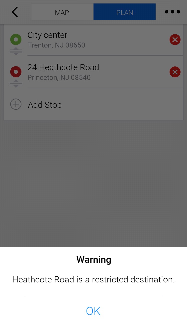
How does routing handle pickup or delivery locations on restricted roads?
When there is a legal or physical restriction at the stop location, our truck routing will generate the route and provide warnings about the restriction. When planning routes with PC*Miler or our cloud-based Routing APIs, these warnings appear in reports. In our CoPilot navigation app:
- A pop-up warning notifies the driver that CoPilot has detected the destination to be on a restricted road.
- CoPilot provides guidance up until the driver reaches the restricted road.
- Once on that road, CoPilot will not provide any guidance and indicate to the driver that they are currently on a restricted road. No further guidance will be provided until CoPilot detects the user has navigated to a legal road.
If the stop is on a road that has truck restrictions but allows deliveries:
- If there is a legal restriction but no physical restriction, CoPilot will navigate to this road as it assumes the driver is on a delivery.
- If the road has a physical restriction based on the truck’s size, CoPilot will not provide guidance as it is unsafe to use that road under any circumstances.
What other special routing situations are considered?
Our truck routing algorithm also takes into account:
- Delivery or pickup stops on roads that are restricted to pedestrians only. In these cases, the route takes the driver up to the point where they would have to park and walk to the stop.
- Time-based road restrictions that are active only during specific times. (For example, roads that are closed during the winter or have a special speed limit in effect.) These restrictions are enabled when you select an arrival or departure time when planning a trip as well as when on active guidance in CoPilot Truck.
Does the user have the option to choose the route?
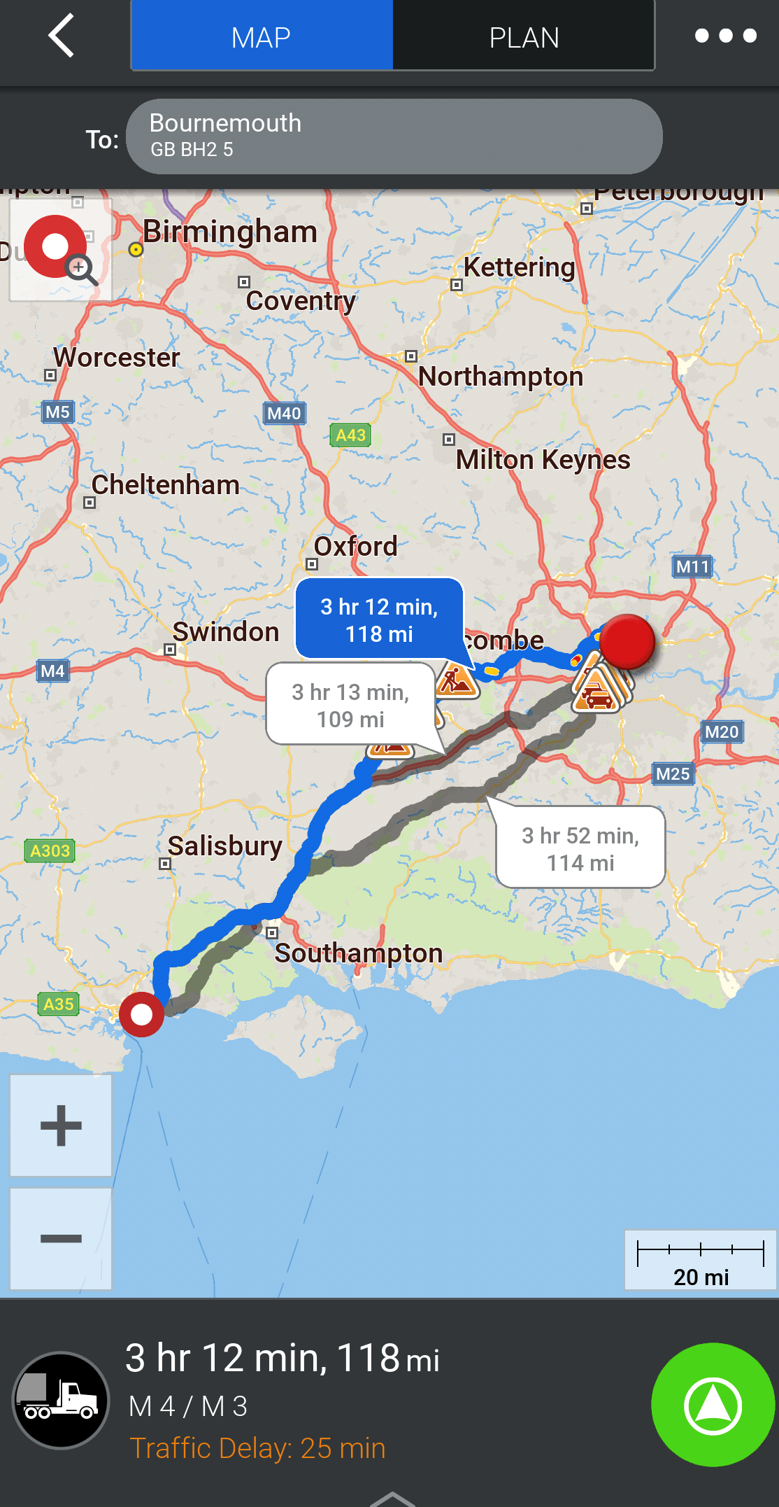
Our applications will always first recommend the best route, based on the vehicle type and Vehicle Routing Profile. Our CoPilot navigation app also provides alternate routes, in the event you want to consider other options.
- In CoPilot, up to three possible routes, including a recommended route and two alternate routes, are shown on the MAP screen after route calculation. Each route displays an estimated time of travel (ETT) and distance.
- In route planning applications, including PC*Miler and our Routing APIs, we offer special features that allow you to compare routes before selecting one. For example, the Least Cost routing feature uses the costs you enter—such as fuel cost per mile and labor cost per hour—to generate a series of possible routes with distance, time and cost estimates. You can then choose an optimal route based on those estimates.
Separately, we offer a licensed add-on feature called RouteSync that allows you to set the exact route a vehicle should follow in situations where route compliance and consistency are essential.
How can truck routing be further enhanced and customized?
Our solutions are enhanced by a suite of web tools that allow you to customize map content that influences truck routing:
- In ContentTools, you can create Sites around a location to dictate the exact entrances, exits and roads that should be used to approach or leave a location, such as a business park, manufacturing plant or warehouse.
- In MapExact, you can make custom edits to our map data to suit your company’s needs—things such as adding new roads or changing attributes for existing roads (speed limits or restrictions.) These edits are private to your fleet.
For more information about routing and related settings, please see our product guides:
Share this article: