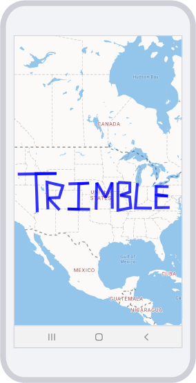
Lines on a map
Contents
The Mobile Maps SDK examples require that you first complete the initial project set-up.
Draw lines on a map using LineString objects.

activity_sample_lines_on_a_map.xml
<?xml version="1.0" encoding="utf-8"?>
<FrameLayout android:layout_height="match_parent"
    xmlns:android="http://schemas.android.com/apk/res/android"
    android:layout_width="match_parent">

    <com.trimblemaps.mapsdk.maps.MapView
        android:id="@+id/mapView"
        android:layout_width="match_parent"
        android:layout_height="match_parent" />

</FrameLayout>
SampleLinesOnAMapActivity.java
Before running the Java or Kotlin code, the theme needs to be set in the Theme.xml file as shown below.
<?xml version="1.0" encoding="utf-8"?>
<resources>
    <style name="Theme.AsyncAcctInit" parent="Theme.AppCompat" />
</resources>
Sample JSON (lines.json)
{
  "type": "FeatureCollection",
  "features": [
    {
      "type": "Feature",
      "properties": {},
      "geometry": {
        "type": "LineString",
        "coordinates": [
          [-119.091796875, 44.08758502824516],
          [-108.80859375, 44.213709909702054],
          [-114.2578125, 44.213709909702054],
          [-113.90625, 36.31512514748051]
        ]
      }
    },
    {
      "type": "Feature",
      "properties": {},
      "geometry": {
        "type": "LineString",
        "coordinates": [
          [-111.09374999999999, 36.94989178681327],
          [-111.357421875, 42.5530802889558],
          [-107.138671875, 41.83682786072714],
          [-108.10546875, 39.36827914916014],
          [-111.005859375, 39.30029918615029],
          [-108.017578125, 36.80928470205937]
        ]
      }
    },
    {
      "type": "Feature",
      "properties": {},
      "geometry": {
        "type": "LineString",
        "coordinates": [
          [-105.64453124999999, 42.22851735620852],
          [-100.1953125, 42.35854391749705],
          [-102.919921875, 42.22851735620852],
          [-103.0078125, 36.94989178681327],
          [-105.908203125, 37.020098201368114],
          [-99.931640625, 36.94989178681327]
        ]
      }
    },
    {
      "type": "Feature",
      "properties": {},
      "geometry": {
        "type": "LineString",
        "coordinates": [
          [-98.349609375, 36.87962060502676],
          [-98.173828125, 42.48830197960227],
          [-95.80078125, 39.33429742980725],
          [-94.0869140625, 42.5530802889558],
          [-94.04296874999999, 37.055177106660814]
        ]
      }
    },
    {
      "type": "Feature",
      "properties": {},
      "geometry": {
        "type": "LineString",
        "coordinates": [
          [-92.548828125, 42.48830197960227],
          [-92.548828125, 36.73888412439431],
          [-89.1650390625, 37.26530995561875],
          [-89.4287109375, 39.50404070558415],
          [-92.021484375, 39.842286020743394],
          [-89.384765625, 40.51379915504413],
          [-89.384765625, 42.391008609205045],
          [-92.493896484375, 42.49640294093705]
        ]
      }
    },
    {
      "type": "Feature",
      "properties": {},
      "geometry": {
        "type": "LineString",
        "coordinates": [
          [-87.4072265625, 42.35854391749705],
          [-87.9345703125, 37.23032838760387],
          [-83.583984375, 37.19533058280065]
        ]
      }
    },
    {
      "type": "Feature",
      "properties": {},
      "geometry": {
        "type": "LineString",
        "coordinates": [
          [-78.837890625, 37.33522435930639],
          [-82.4853515625, 37.3002752813443],
          [-82.44140625, 39.774769485295465],
          [-79.27734374999999, 39.70718665682654],
          [-82.44140625, 40.01078714046552],
          [-82.3974609375, 41.705728515237524],
          [-79.1455078125, 41.672911819602085]
        ]
      }
    }
  ]
}