Fuel-related reports
Contents
PC*Miler’s Derived Route API can return two reports that help fleets manage diesel fuel costs and improve driver safety:
- The Fuel Tax Report accepts GPS pings, matches them to the road network, calculates the distance traveled on each road segment, and returns distance totals by jurisdiction. This helps you calculate fuel taxes for each U.S. state and Canadian province and avoid overpayment from GPS mileage inflation.
- (Requires add-on license) The Speed Limit Report accepts GPS pings, matches them to the road network, and returns the truck speed limit for each ping. This data can help you coach drivers, lower fuel costs, and reduce tire wear and maintenance needs. For example, driving at 75 mph instead of 65 mph can increase fuel use by up to 27%, according to American Trucking Associations (ATA).
What is a derived route?
A derived route is the estimated route a vehicle took based on a series of latitude and longitude GPS pings. You send the pings to the Derived Route API as an array of RoutePings. The PC*Miler algorithm calculates the route path using either:
- Default vehicle dimensions and default settings, or
- Custom route options and reporting options passed with the pings.
Cleaning up the pings
Ideally, pings are provided for at least every 10 minutes while the engine is running. For accuracy of snapping to the correct road segment, the GPS stream should also contain speed and heading.
For each GPS ping in the request, the routing algorithm finds the most likely route based on its location and places the ping on that route. It tracks movement along the route and matches each coordinate to the nearest valid road segment.
The API returns a SnappedLocation for each ping. This location corrects GPS drift, including drift toward a parallel road, and provides more accurate data by matching each coordinate to the nearest valid road segment.
Fuel Tax Report
Interstate carriers operating under IFTA must report miles traveled in each U.S. state and Canadian province. Telematics systems collect GPS at regular intervals, but raw coordinates alone are unreliable for jurisdiction mileage when GPS drifts off the actual driven path.
The Fuel Tax Report works this way:
- The derived route is calculated based on a series of GPS pings.
- Corrected coordinates are calculated for pings that have “drifted” from the route.
- Distances are calculated between each of the derived or corrected pings along the route.
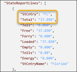
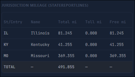
- The calculated distances are then aggregated by state or province and returned in the report output’s
StateReportLinesobject as jurisdiction-level totals for fuel tax reporting.
Use case
When GPS pings snap to the wrong road, standard consecutive-pair mileage APIs can double-count distance. This produces fuel tax liability on miles the truck never drove.
The Fuel Tax Report corrects GPS drift by comparing consecutive pings to expected travel paths on the PC*Miler road network. During IFTA calculations, it can be used to validate odometer miles, while accurately reporting miles in each jurisdiction. IFTA taxes miles driven in each state, not where diesel was bought.
Speed Limit Report
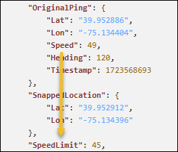
The API is passed a series of GPS pings. Each ping should include the truck’s coordinates, speed, heading, and time.
It returns the OriginalPing, the SnappedLocation for the route path, and the associated SpeedLimit for that location. To help ensure only relevant speed limit data is provided, speed limits are not returned for the following road segments: the origin and destination, and any roads classified as ramps or pathways.
Use case
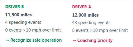
With the speed limit data, your platform can then apply its own thresholds to identify drivers who are performing well and those whose speeding might be a safety or fuel consumption issue. For example, looking at speed events 10 or more mph over the the speed limit, you may find: